(click on any project title to learn more—click title again to close it)
Fort Clatsop GPR
On a sunny April 16, 2022, over 25 Oregon Chapter members and guests visited Fort Clatsop and watched an effort to find the exact location of the fort through a ground-penetrating radar survey. Chapter president and chief instigator Glen Kirkpatrick gave a talk on why a new area has been chosen for the GPR survey, followed by a presentation by Dr. Colin Grier, Washington State University Associate Professor of Archeology, whose team of graduate students is conducting the survey. NPS staff explained the permitting process. A second survey was conducted in the summer, then results were analyzed to determine whether any evidence remains in the soil of the fort’s pickets—perhaps on the edge of the bench on which the “defensive fort” stood.
Click to view PDF
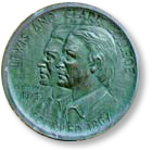
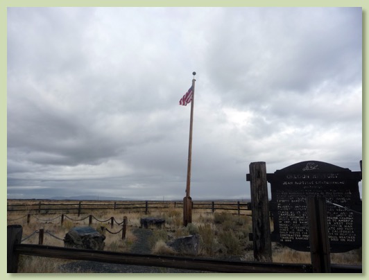
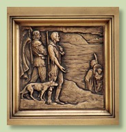
Jean-Baptiste Charbonneau Gravesite Restoration
Goal: To prepare a landscape design plan for the restoration end enhancement of the gravesite area, including suggestions for a wayside rest area, toilet and interpretive signage on nearby Oregon State Highway 95. To assist in the future construction and refurbishing program for the site and seek transfer to, or permanent maintenance by, a public agency. This project was conceived by the late Roger Wendlick, who had led previous restoration work at the site culminating in a 2000 rededication.
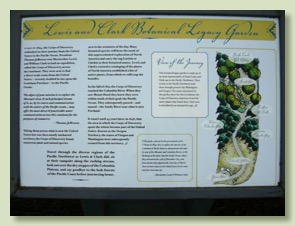
Lewis & Clark Botanical Legacy Garden
Lewis & Clark Educational Programs
Goal: To find the ways and means to assist and encourage local schools, libraries and other institutions in educational pursuits and curricula related to the Lewis & Clark Expedition.

Education Fund
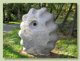
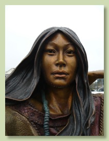
The Oregon Chapter funds local schools’ participation in Lewis & Clark related activities in the area.In 2005, in time for the national foundation’s annual meeting, we dedicated the "Blue Lake" project, which installed monumental art commemorating the tribal village site in Metro’s Blue Lake Park along the Columbia River. The picture at right is a carving of one of the two plankhouse posts honoring the village of Nichaqwli, where the guide lived who led Captain Clark back down to the Willamette River in April, 1806. Other artworks include a wooden bench evoking a canoe and a large stone sculpture representing an outsized fishing weight. Our chapter led the fundraising, design, and installation. In 2013 we added an interpretive panel to explain the meaning and importance of the art and village.
We have been given a grant of $2500 to do curriculum work for schools on this site and to explain its meaning.
Lewis & Clark on the Columbia River - Map-Guide Update
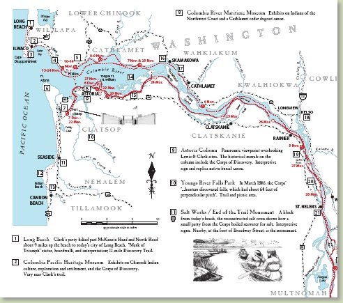
Map Available for Download on the Maps Page
In 2013 our chapter updated the Columbia River map-guide first published in 2001 by Lewis & Clark Bicentennial in Oregon. It provides basic information on the Lewis & Clark Trail in Oregon and Washington to guide tourists to locations of interest and explain the Corps' experience here. It folds to 3-5/8" x 8.5", to fit in a brochure rack.
Through the state tourism commissions, LCBO distributed 75,000 copies in 2001-2004 to visitor centers, museums, interpretive centers, and other interested institutions across Oregon and Washington.
Our update reflects the changes over the past 12 years—some sites have been added, some removed; facilities have changed their names or exhibits; and recent scholarship has improved our knowledge of Lewis & Clark campsites. The Confluence Project installations are included and the new Lewis & Clark National Historical Park designation has been added. We received generous grants from the national foundation and from the National Park Service to print the 2013 version—now in color.
Experts in the Oregon and Washington chapters and at NPS contributed their knowledge and insights. They include: Jeff Davis, Glen Kirkpatrick, Steven McClure, Roger Wendlick (Oregon); Rob Heacock, Barb Kubik, Steve Wang (Washington); and Dick Basch, Ryan Cooper, Suzanne Gucciardo, Karla Sigala (National Park Service). The designer/cartographer, Connie Snow, who created the 2001 version, repeated her role.
The map-guide traces the entire Lewis & Clark Trail down the Columbia River, plus side-explorations by Clark in several locations. It was the first major map to show both Oregon and Washington sites (previously each state would leave the other's sides off the map) and to show the names of the native homelands through which the Corps traveled.
The publication date was June 2013, with free distribution of 40,000 all along the Lewis & Clark Trail in Oregon and Washington. Institutions wanting a supply should contact TedKaye@or-lcthf.org. The chapter encourages anyone to download and print it—it fits on 11”x17” paper.
Oregon Lewis & Clark Boy Scout Patch
The Oregon Chapter encourages youth organizations to learn more about the Lewis & Clark Expedition. In 2010 we introduced an embroidered patch, similar to those offered by other Chapters along the trail. The patch can be earned by Cub Scouts, Boy Scouts, Varsity Scouts, Explorers, and Venturers. See HERE for the requirements to earn this popular patch.
Oregon Lewis & Clark Inventory
U.S. National Bank,
Portland
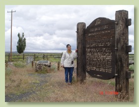
Gravesite, Danner
Blue Lake Park, Portland
Our Chapter thanks the tireless researchers who visited all the assets and brought back important information on each one:
Cascade Locks
Dave Ellingson
Arnetta Guion
Thelma Haggenmiller & Jerry Herrmann
Mark Johnson
Mary Johnson
Glen Kirkpatrick
Jane Richardson & Lois Roby
Mike VonDerahe
Brad Yazzolino
- Eventually, it is hoped that this trail-wide data will be publicly available. For the time being, it is helping to inform decisions about investments along the L&C Trail. Our Chapter has made an important contribution to this work.
Tongue Point Interpretation & Memorial
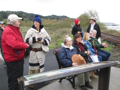
Attendees at the dedication event enjoy the bench in memory of Keith Hay,
next to the interpretive panel, along the Astoria River Walk and the Columbia River
Lewis & Clark camped on the neck of Tongue Point (Point William) 11/27–12/6/1805, and again on its east side 3/13/1806. It is one of very few sites along the entire Trail where the Corps stayed for more than a week. In November 2015, at the end of the Astoria River Walk overlooking the river and Tongue Point, our chapter installed an interpretive sign and a bench in memory of Keith Hay.
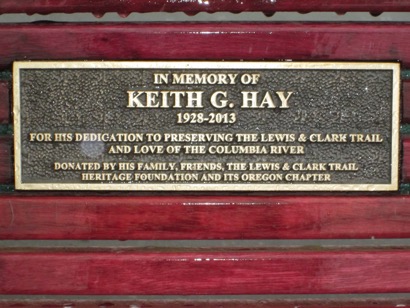
As a secure federal location (Coast Guard and Job Corps) Tongue Point is otherwise inaccessible, so our interpretation helps visitors understand and appreciate its importance to the Corps of Discovery. Our chapter’s founder, Keith Hay, died in 2013. His seminal work in 1962–66 with the Department of the Interior to map the L&C trail across 10 states led to the creation of the L&C National Historic Trail, and thus to the foundation and this chapter. A bench along his beloved Columbia River, along with an interpretive panel, serves as a fitting memorial. Much of the cost of this project was funded by a $6,300 grant from the foundation’s Trail Stewardship Endowment, supplemented with gifts received by the Chapter in memory of Keith.
Website
Members of the Board each take responsibility for sections of the website, checking on them and suggesting additions, changes or corrections.Goal: To produce a comprehensive website with maps and interpretive information. The website is continuously refined from public input and provides travelers with an invaluable source of updated information, at no cost.
Education Fund: Larry McClure
President's Message: Glen Kirkpatrick
Projects: Ted Kaye and Glen Kirkpatrick
Pictures: Ted Kaye (and all photographers)
Events: Thelma Haggenmiller and Lyn Trainer
Accuracy: Ted Kaye, Glen Kirkpatrick (all Board Members are part of this subgroup)
Press Releases: Mark Johnson