August 9, 1805–October 10, 1805
Meeting the Salish
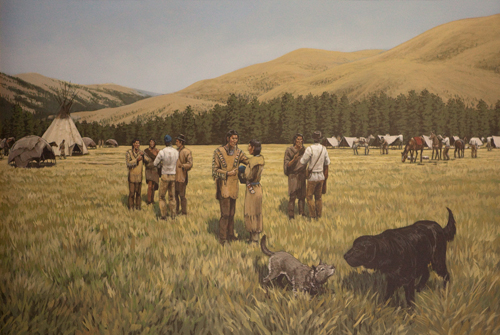
Painting created by Split Rock Studios now in the collection of the Lewis and Clark Trail Heritage Foundation. Photo © 2011 Kris Townsend.
Shoshone
On August 9, the members of the Corps of Discovery were rigorously pushing and pulling their canoes up the Jefferson River, the section now known as the Beaverhead. They were just a few miles above modern-day Ruby Creek.
Meriwether Lewis and three other men, Drouillard, Shields, and McNeal, had left by land in an attempt to locate the Shoshone Indians. They were certain they would need horses to begin what they thought would be a short portage from the headwaters of the Missouri to a river they could successfully navigate to the Pacific Ocean.
Lewis and William Clark had agreed that Clark and the remainder of the party would continue up the river in the canoes to the next fork, where Lewis would eventually rejoin them.
On August 11, Lewis encountered the first Shoshone Indian. He approached cautiously, managing to get within 150 paces of the wary young native. Suddenly, the Indian fled.
Lewis and his men first entered Idaho on August 13, near the headwaters of Pattee Creek, where they surprised a group of Shoshone women and children. Most of the frightened Indians ran and hid, but one elderly woman, accompanied by a young girl, sat down, apparently expecting to be killed. Lewis instead presented them with some small gifts, then painted their faces with vermilion, a sign of peace.
Lewis and his associates were following the pair to their village when 60 warriors arrived. After exchanging sign-language greetings, the Indian smoked Lewis's pipe before accepting a few presents. The Shoshone chief, Cameahwait, led the men to his camp on the Lemhi River, located about 7 miles north of the present-day town of Tendoy.
The Shoshone were impoverished and had very little to eat. They did, however, have a surplus of good horses. Lewis and his men introduced themselves, then described their journey and the purpose of the expedition. The Indians insisted that the river they were on could not be navigated, and that there was no established trail adjacent to the shoreline. This was not good news.
By midday on August 15, Lewis and his party, escorted by Chief Cameahwait and a small band of warriors, traveled over the Lemhi Pass, moving toward the prearranged campsite and their reunion with Clark. By now, the Indians had grown suspicious of Lewis, and were concerned that he may be leading them out on the prairie to be ambushed by their enemies.
On August 16, as they approached the campsite, Lewis quickly realized that Clark had not yet arrived. He was afraid that the Indians were going to abandon him, so he captured their interest by promising a meeting with "the woman of their nation" (Sacagawea), and by describing a "black man," namely York, Clark's slave.
The following morning, Lewis sent Drouillard and one Indian downstream to locate Clark. A short while later, the Indian returned, speaking and gesturing excitedly. Within hours, Clark and the remaining party members arrived just below the forks. (This site is now submerged beneath the waters of the Clark Canyon Reservoir.) Interestingly, it was soon discovered that Sacagawea was, in fact, the Chiefs sister.
On August 18, Clark, accompanied by one-third of the Corps of Discovery and a handful of Indians, started back in the direction of Lewis's River, now known as the Salmon River. They had acquired two horses, and they optimistically brought a number of axes, intending to build canoes if they determined the river could be navigated.
Clark crossed the Lemhi Pass on August 19 and hired an old Indian guide by the name of Toby. They proceeded down the Lemhi and Salmon Rivers and, on August 22, they arrived at the north fork. Here, Toby described a route over the mountains leading to the mighty Missouri. Clark continued down the Salmon, and on August 24, concluded that the Indians were correct—the river could not be navigated.
Clark wrote a letter to Lewis, suggesting that he purchase a horse for every man, and attempt to proceed overland to some undiscovered river that may provide safe access to the ocean. He dispatched Colter to deliver the message.
Lewis stayed at the campsite at Camp Fortunate until August 24. He cached the excess baggage, sank the canoes in a nearby pond, and purchased nine horses and a mule. He also hired two Indian horses and, by noon, they had loaded most of their supplies onto the animals, dividing the remaining items among the Indian women, who carried the surplus. They traveled just six miles on this day.
On August 26, Lewis arrived on the Lemhi River, where he met Colter and received Clark's letter. After considering Clark's suggestions, Lewis attempted to purchase 20 additional horses from Cameahwait. Unfortunately, the Chief refused to do business, which greatly upset Lewis.
(From August 26 until September 9, Lewis failed to make any new entries in his journals. He wrote again on September 9 and 10, and from September 18 through the 22nd.)
On August 29, Lewis and Clark were once again reunited on the Lemhi, about 4 miles north of Tendoy. The next morning, the Corps of Discovery set out with 29 horses. Many of the horses were in poor condition, suffering from sore backs, while others had not been properly broken and used for packing. Their Indian guide, Toby, was also on hand, having agreed to guide them over the mountains.
Salish
On September 2, they started up the north fork of the Lewis's River (Salmon River). The route was extremely rough, and inclement weather, including heavy rains and intermittent snow flurries, made travel hazardous. On September 4, the party crossed over into the headwaters of the Bitterroot Valley.
Later that evening, they encountered a large band of Salish-Flathead Indians. A total of 400 persons, including 80 men, inhabited 33 lodges. Nearly 500 horses grazed in the surrounding meadows. These Indians were very friendly and hospitable. They were subsisting on nothing but berries, but despite their hunger, they happily smoked the pipe with Lewis and Clark and visited until the wee hours of the morning.
A Salish-Flathead narrative, recorded 90 years later, tells the tale of Chief Three Eagles, who was reportedly out scouting for enemies when he initially spotted the explorers. Lewis and Clark were riding ahead, while the remainder of the party were leading their horses. The Chief was puzzled and intrigued by the strangers. They did not wear blankets, as all Indians did, and he wondered if York, Clark's slave, was a fierce warrior, his face painted black as a sign of aggression. Chief Three Eagles ultimately decided by the casual manner in which they were traveling, that these new arrivals bore no hostile intentions. As a result, the tribe welcomed them with open arms.
On September 5, Lewis purchased 11 healthy horses and traded seven "indifferent" pack horses for some excellent horses. Two more horses were purchased the following day.
The Corps of Discovery now had 40 fine horses and 3 colts. The Salish-Flathead tribe furnished half of the horses needed to traverse the mountains.
Lolo Crossing
At 2:00 on September 6, Lewis and Clark started down the Bitterroot Valley and, simultaneously, the Indians left for the Three Forks to hunt with the Shoshone. As they proceeded down the valley, adjacent to Clark's River, they lost a horse or two, but managed to find two mares and a colt, which they claimed and took along.
The men arrived at a creek on September 9, and Toby informed them that they would now have to leave the river and proceed up the creek and over the mountains. They called this place "Traveller's Rest." It is located near the present-day town of Lolo, Montana. They resolved to spend the next day in this area, to hunt, rest the horses, and make scientific observations.
On September 10, Colter was hunting in the vicinity of Lolo Creek when he came upon three Indians. He invited them to visit his campsite, and the young warriors accepted. They explained that they were pursuing some Shoshone tribesmen who had stolen several of their horses. These Indians said they lived on the opposite side of the mountains, and they assured Lewis and Clark that the river could be successfully navigated, all the way to the ocean. The Indians also indicated that their people had metal kettles and other items obtained from white traders living near the coast. These Indians were the first Chopunnish, or Nez Perce, the explorers met.
After enjoying a meal of boiled venison, two of the Indians left, renewing their search for the Shoshone horse thieves. The third warrior agreed to guide the party over the mountains, saying the journey would last "five sleeps."
On September 11, the men were detained until 3:00 as they struggled to collect their horses. The Nez Perce warrior who had consented to guide them over the mountains became impatient and fled. Undaunted, the courageous Corps of Discovery proceeded up Lolo Creek and, on September 13, they once again entered Idaho, near Lolo Pass. They noted stupendous, snow-covered peaks, then crossed through the Packer Meadows and camped in a glade.
On September 14, they took the wrong route. Although they should have taken a trail which forded modern-day Crooked Fork, and continued over Rocky Point, instead they followed a path which the Salish-Flathead used in their travels to the river. (This trail is situated near the Powell Ranger Station and was a prime location for salmon fishing.) The men straggled down the ridge between Pack Creek and Haskell Creek, then crossed the Brushy Fork and climbed up the slope toward the Beaver Ridge Lookout. They pressed on, heading back down the ridge to the mouth of Killed Colt Creek, then crossing the Kooskooske River. They finally camped near the Powell Ranger Station. Near starvation, they tried to eat some of the "portable soup" they'd brought along, but found it very distasteful, so they killed one of their colts for supper. During the day, while the men were hunting, they discovered a horse, and later that evening, a small pony wandered into camp.
On September 15, the explorers continued down the river to the approximate location of the Wendover Campground. Here the trail advanced upward, to the dividing ridge between the Kooskooske and the Chopunnish Rivers, now known as the Middle Fork of the Clearwater River. As they climbed up Wendover Ridge, which was extraordinarily steep, several of the horses fell and were injured. Two of the horses were so seriously hurt that they were left behind. Clark's small, portable desk, which he had transported from St. Louis, was destroyed.
In the evening, they were unable to find any water, so the men camped beside a snow bank left over from the previous winter. They melted the snow to make more of the portable soup, and to boil the remainder of their horse meat.
On the morning of September 16, the men awoke to nearly six inches of new-fallen snow. Suddenly, they found themselves barely able to locate the trail, and visibility had dwindled to just 200 yards. Clark, however, managed to see a black-tailed deer. He attempted firing his gun 7 times at the large buck, but it did not fire; the result of a loose flint. This was the last game they observed until Clark's hunters bagged a few deer near Orofino.
At 12:00, Clark and one man traveled ahead. Near Indian Post Office, they left the ridge and trekked to a narrow stream bottom where they found a cove scarcely large enough for the party to camp and built fires. The main party arrived about dark. Another colt was killed and eaten that evening.
September 17 brought rising temperatures and melting snow, and shallow pools of cold water covered the trail in many places. The men crossed a ridge, then dropped down into Gravey Creek, somewhere near the mouth of Mier Creek. From here, they progressed once more to the dividing ridge, then camped near a series of sinque (sic) holes brimming with water. The third and last colt was slaughtered for the evening's meal.
By the morning of September 18, Lewis and Clark had decided to separate. Clark took the party's six best hunters and rode ahead to search for game. Clark and his men continued along the main ridge over Bald Mountain. They climbed Sherman Peak and, looking to the west, they could see a prairie, which they called the Columbian Prairie. This area is now called the Camas Prairie.
Clark's hunting party advanced across Sherman Saddle and over Willow Ridge, then proceeded to a wide, bold running creek, flowing east. Because the men were famished, had found no wild game and had nothing to eat, the fast-moving stream was named Hungery Creek.
On September 19, Clark and his men proceeded upstream. In a nearby meadow, they discovered a horse, which they butchered, preparing a hearty meal for themselves. They divided the leftover meat, reserving a portion for themselves, and leaving the excess for Lewis and the remaining members of the expedition.
The hunters continued up Hungery Creek, traveling only a short distance before crossing over into the headwaters of Fish Creek. They entered the Eldorado Creek drainage, maneuvered down the ridge between Dollar Creek and Six Bit Creek, then rode adjacent to Eldorado Creek for two miles. From here, the men went up and over a ridge, then dropped down into Cedar Creek to the Lewis and Clark Grove, where they camped.
Nez Perce, First Encounter
The following day, Clark and his men proceeded to the next ridge, and down to the forks of Lolo Creek and Eldorado Creek, which was subsequently renamed Collins Creek. They continued downstream approximately two miles, cut across to Crane Meadows, climbed the lower end of Brown's Ridge, then descended into Miles Creek.
As the party made their way along Miles Creek, they came upon three Indian boys. Terrified, the children tried to conceal themselves in the tall grass, but Clark found two of the boys, calmed them, and presented them with ribbons and other small trinkets. The men trailed the youths to an encampment on the Weippe Prairie where they were greeted by a group of congenial women and old men, who explained that the tribe's younger braves had ridden off to battle. The men gratefully shared a meal of camas, dried fish and meat.
At dusk, Clark and the hunters traveled two more miles across the prairie, arriving at a second Indian encampment, where the women were busily digging and roasting camas. Several lodges and dozens of horses dotted the landscape. Another creek, which Clark called Village's Creek, now known as Jim Ford Creek, meandered near the campsite. The party remained here overnight.
On the September 21, Clark began gathering information about the area and the river. He purchased a large quantity of camas and dried fish to send back to Lewis. Unfortunately, most of the undernourished men were sickened by their new diet of fish and roots.
At 4:00, Clark and the men, with the exception of Reuben Field who'd been consigned to deliver the food to Lewis, collected their supplies and left for the river. They traveled in a westerly direction, passing through Frazer. Near nightfall, they met an Indian who agreed to guide them in exchange for a handkerchief. They followed the Indian down a ridge, to the mouth of Jim Ford Creek, then downriver to China Island, approximately ½ mile above a creek which Clark named Rock Dam Creek, now called Orofino Creek. A number of Indian women and children were camped here, including one woman, a former captive of the Minnetaree, who reported that she had been treated well by white men.
Their Indian guide shouted to an old Chief camped on a small island, who responded by returning to shore. The Chief, who appeared to be about 65 years of age, was called The Twisted Hair.
The next morning, while the others were hunting, Clark and Twisted Hair began the return trip to the Weippe Prairie, where they would reunite with Lewis.
(Meanwhile, back at the Sinque Hole camp . . . . . . .)
On September 18, Lewis and the remaining party members were detained because of a missing horse which, regrettably, was never recovered. They followed the same route Clark had taken, camped somewhere between Bald Mountain and No-see-um Meadows on the ridge, then descended into a steep ravine to collect fresh water. The men, nearing starvation, once again ate portable soup.
On September 19, they climbed Sherman Peak, taking note of the Camas Prairie in the distance. That evening, Lewis and his men stayed at Hungery Creek.
On the morning of September 20, they proceeded upstream and discovered the horse which Clark had killed. They loaded the meat, then traveled a short distance to the headwaters of Fish Creek, where they prepared a satisfying meal. Afterward, they continued on to the ridge between Dollar Creek and Six Bit Creek and set up camp. The next day, September 21, they traced Clark's route and camped adjacent to Collins Creek (Idaho's Lolo Creek). Here, Lewis killed a "prairie wolf" (coyote) and a pheasant. The men also managed to catch a few crayfish, which they cooked and ate for supper.
Lewis and his crew left Collins Creek on September 22. They met Reuben Field, his pack-horse loaded with fish and camas, at Crane Meadows. The men enjoyed a fine meal, allowing the horses to graze before pressing on to the Camas Flats (Weippe). At the village where Clark and the hunters first met the Chopunnish, or Nez Perce, Lewis happily came upon Clark, accompanied by Chief Twisted Hair. While the men made camp, Clark cautioned them against eating too much.
On September 23, the explorers spent the afternoon gathering information and making maps. In the evening, they traveled two miles to the second Indian village and camped. The next day, September 24, they left Weippe, and proceeded to China Island, where they stayed overnight.
Canoe Camp
Clark, Twisted Hair, and another Indian rode along the north bank of the river to the forks, then crossed the Kooskooske [Clearwater River], where Clark found a stand of long-leaved (Ponderosa) pine that were large enough to fashion into canoes. The men camped, for the second evening, at China Island.
On September 26, the men traveled a short distance, then forded Rock Dam Creek. They subsequently crossed the river near the present-day airport, then proceeded down the south side to Canoe Camp.
By September 27, although most of the men were ill, they made handles for their ax heads, felled five trees, and began the arduous task of building canoes.
The men continued to work on the canoes for several days. The Indians, eager to assist, demonstrated a method of burning out, rather than chopping the logs, which proved to be quite a time saver. On October 2, still sick and weak from eating the roots and salmon, the men once again killed and ate a horse for supper.
Two days later, on October 4, the explorers were out of meat again. The hunters had been unsuccessful, so they bought a dog which they butchered and consumed. (Although this is the first journal entry referring to the purchase of a dog, Lewis and Clark bought and ate many dogs en route to the ocean and during the return trip to Idaho in 1806.)
On October 5, Twisted Hair consented to keep their horses throughout the winter. Thirty-eight horses were branded, and two canoes were completed that day. The men also took time to bury their saddles, some gun powder and shot. That evening, Twisted Hair and another Chief, Tetaharsky, agreed to guide them to the falls on the Columbia River.
Down the Clearwater
By October 7, a total of five canoes were finished and loaded with supplies. Chief Twisted Hair and the other Chief was not in the area at 3:00, the men pushed their narrow boats into the river and resumed their journey without their guides. A short distance from Canoe Camp, the men encountered raging rapids which damaged some of the canoes. They came ashore near the present-day town of Lenore, where they repaired the boats and made camp for the evening.
On October 8, the men buried two canisters of gun powder 2 feet 3 inches from a pine tree with a distinctive dead top. They launched the canoes and paddled downriver, maneuvering through a series of rapids and drifting past several small islands. Near the mouth of the present-day Cottonwood Creek they found Twisted Hair and Tetaharsky at an Indian village; they took them on board. Just below Colter Creek, the canoe piloted by Sergeant Gass capsized and sank. The vessel was severely damaged, and some of the articles on board were lost. The party struggled to shore, then set up camp. The afternoon was spent drying wet clothing and supplies.
Their Indian guide, Old Toby, inexplicably left the expedition on October 9. When the guide and his son, who had also accompanied the men, were seen heading upriver, Clark asked Twisted Hair to send a horseman to catch Toby so they could pay him for services rendered. The Chief advised Clark not to pay Toby, insisting that the Chopunnish nation would, undoubtedly, steal Toby's things before he passed their camps.
On the morning of October 10, the men loaded their supplies and set out at 7:00, accompanied by Twisted Hair and Tetoharsky. After navigating through more rapids and past a handful of islands, they arrived at Lewis's River, now known as the Snake River. They made note of log shelters built by the Indians and camped on the north side of the Snake River, just below Clarkston.
The explorers continued down, first, the Snake, and then, the Columbia Rivers. Twisted Hair and Tetoharsky remained with the party until they reached Celilo Falls near The Dalles, Oregon. Both Chiefs were able to communicate with all of the Indians they encountered during the trip, assuring them that the Corps of Discovery had only peaceful intentions.
Information taken from the Journals of Lewis & Clark Expedition, Gary E. Moulton, Editor, University of Nebraska Press.