Potlatch River (Coulter Creek): Much happened in a small area
A small section of the Clearwater River hosted a series of events for the Corps of Discovery in the fall of 1805 and the spring of 1806:
- Their second day in canoes resulted in a wreck with extended consequences.
- Returning upriver in the spring a good meal in the form of a horse was lost and expedition members had a dispute. Was it over the missing meal?
- War Axes built by the party’s blacksmiths at Fort Mandan were found in a local village; how did they get there?
- Capt Lewis trained to be the medical person in Philadelphia but Capt Clark was earning their food by treating Nez Perce medical problems.
- Ninety years later a Jefferson Peace Metal was discovered in an Indian grave site by Railroad construction crews.
Canoe Wreck: Different stories of the same event
Today’s Potlatch River (L&C: Coulter Creek) joins the Clearwater River about 12 miles east of Lewiston. Highway 12 crosses the Clearwater River just below the mouth of Potlatch River on what today is called Arrow Bridge. In September 1806 the Corps of Discovery canoeing down river wrecked one canoe, probably just below the small island located just above the bridge. They camped on the north side of the river downstream from the bridge in today’s highway department storage yard. This photo from Goggle Earth appears to have been taken in mid-summer when the river was much higher than it would have been in September.
From the journals 8 Oct 1805
Following are different journal entries made about the canoe wreck including that by Sgt. Gass who was steering the canoe. Note how his description differs from the others.
Ordway: decended a rockey rapid at the foot of an island where was several Indian camps. One of the canoes struck a rock in the middle of the rapid and swang round and struck another rock and cracked hir so that it filled with water. The waves roared over the rocks and some of the men could not swim. Their they stayed in this dolefull situation untill we unloaded one of the other canoes and went and released them. 2 indians went in a canoe to their assistance also. We got the men and the most of the baggage safe to shore. A iew articles lost one tommahawk and a fiew light things. We put the baggage out and camped on the stard . side at high plains.
Whitehouse: as were decending a rockey rapids at the foot of an island on which was some indian camps, one of the canoes struck a rock and wheeld round then struck again and cracked the canoe and was near splitting hir in too. Throwed the stearsman over board, who with difficulty got to the canoe again, but she soon filled with water, and hang on the rocks in a dolefull situation. Some of the men on board could not swim, and them that could had no chance for the waves and rocks. An indian went in a small canoe to their assistance. Our little canoe went also and took out some of the loading, and carried it to shore. We unloaded one of the other canoes and went in the rapid and took the loading all out of the canoe which was stove and got all to shore below the rapid, and camped at dark. Examined found everry thing wet which was in the canoe that was stove. Some small articles lost
Clark: Set out at 9 oclock passed 15 rapids four islands and a creek on the Stard Side at 16 miles just below which one canoe in which Serjt. Gass was stearing and was nearle turning over, she sprung a leak or split open on one side and bottom filled with water & sunk on the rapid, the men, several of which could not swim hung on to the canoe, I had one of the other canoes unloaded & with the assistance of our small canoe and one Indian canoe took out every thing & got toed the empty canoe on shore, one man Tompson a little hurt, every thing wet perticularly the greater part of our small stock of merchindize, had everything opened
Gass: At 2 we proceeded on again. In the evening, in passing through a rapid, I had my canoe stove, and she sunk. Fortunately, the water was not more than waist deep, so our lives and baggage were saved, though the latter was wet. We halted and encamped here to repair the canoe, after coming 18 miles.
From the journals 9 Oct 1805
Ordway: we delayted to repair the canoe and dry the baggage & C....We got the canoe repaired in the evening
Clark: The morning cool as usual the greater part of the day proved to be cloudy, which was unfovourable for drying our things & c. which got wet yesterday. In examoning our canoe found that by putting Knees & Strong pieces pinned to her sides and bottom she could be made fit for service by the time the goods dried. Set 4 men to work at her, serjt. Pryor & Gass, Jo Fields & Gibson, others to collect rosin, at 1 oclock she was finished stronger than ever. The wet articles not sufficiently dried to pack up obliged us to delay another night.
Gass: We stayed here during the whole of this day, which was very pleasant, and repaird our canoe. In the evening we got her completed and all the baggage dry.
The Rest of the Story: We benefit from the Unintended Consequences
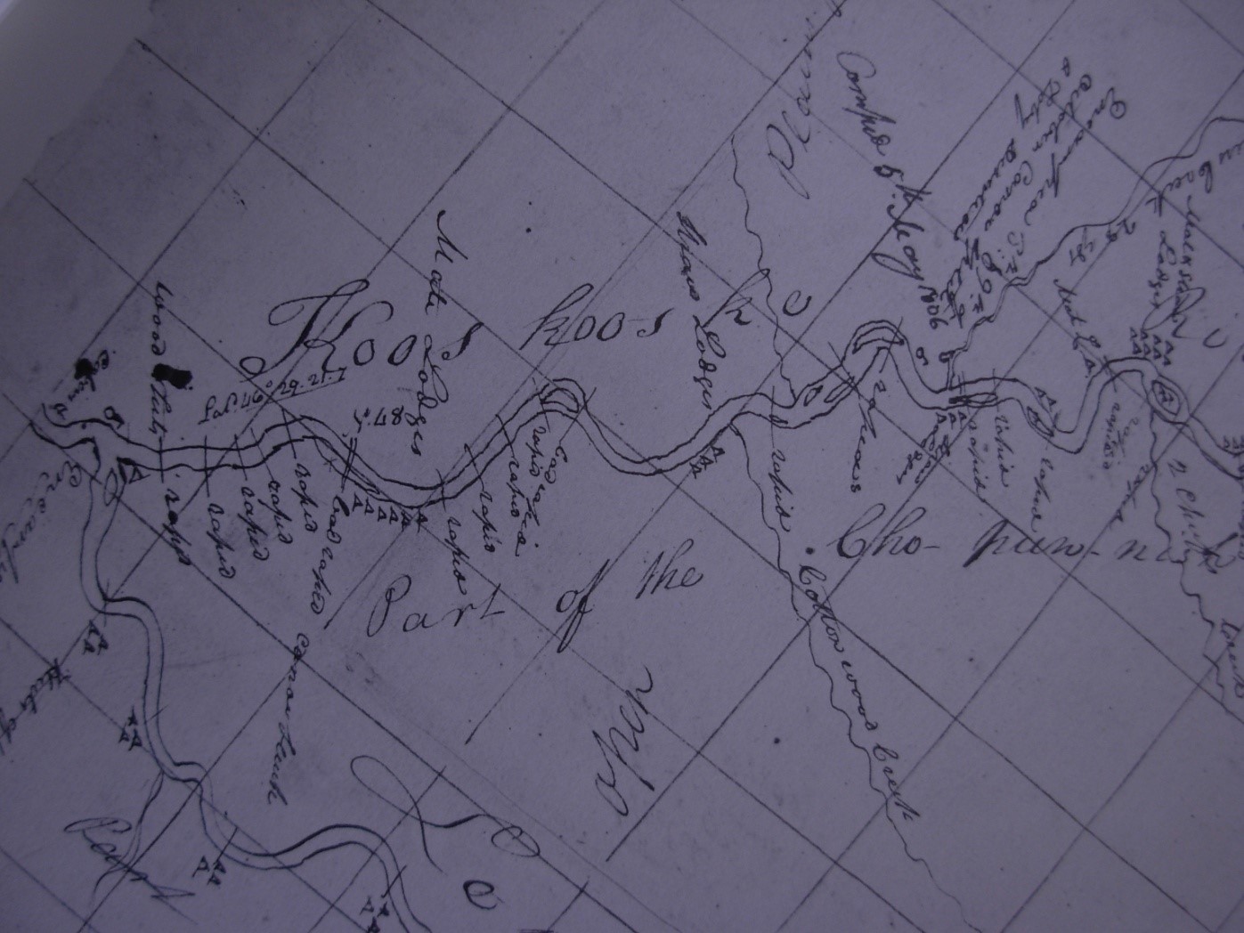
Because of the wreck Capt Clark had extra time to create a much better map of the Clearwater River than would have been available otherwise. He used a two mile grid that shows every bend and Indian village. You can lay this map along a modern map and all the river bends and significant places are shown. The left edge shows the confluence of the Snake and Clearwater Rivers. Clark made notes and probably made the map at Fort Clatsop during the winter. We think he added to the map as they returned east in the spring of 1806. If you examine the map closely you can see different entries facing different directions. Also, the pens made from waterfowl quills wear rapidly, so entries made on different days will look different.
Return Visit
In May 1806 the expedition returned to the area on their way east. They were traveling up the Clearwater River because they had cashed supplies in two places along the river on their way west the previous year. After crossing the Snake River about 7 miles below present day Lewiston, they camped a few miles below the confluence of the Snake (Lewis) and Clearwater Rivers. May 5, 1806 they continued up river and camped near the mouth of today’s Potlatch Creek. The map only shows one symbol for a campsite. Today we wonder did they camp in the same place or in 1806 did they camp a little further upstream? From Clark’s journal it would appear that it was upstream and Clark didn’t bother to add a 2nd camp symbol to a piece of map already cluttered with information.
Clark May 5th, 1806: about ½ a mile above the rapid where we Sunk the 1st Canoe as we decended the river last fall. We encamped on the lower Side of this Creek a little distance from two Lodges of the Chopunnish nation … One of those Lodges Contained 8 families, the other was much the largest we have yet seen. It is 156 feet long and about 15 feet wide built of mats and Straw, in the form of the roof of a house having a number of Small dores on each side, is closed at the ends and without divisions in the intermediate Space. This lodge at least 30 families. Their fires are kindled in a row in the Center of the Lodge and about 10 feet asunder. All the Lodges of these people are formed in this manner.
You can view the probable location of this large lodge by turning off Highway 12 onto SR 3 and stop at the first wide pullout with a hill between the turnout and the creek. Walk to the top of the hill and look down on the mouth of Coulter’s Creek. To your left you will see a field. Was this the location of the large lodge? Some locals believe the Indian homes might have been further up the creek to get better weather protection during the winter. However, the next field or level area is on the other side of the creek and Clark said the "lower" side of the creek. Perhaps their 1806 camp was about where the bridge crosses the river.