Pine Creek to Lenore via Cherrylane Road
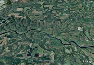
Figure 1. Looking north at the Clearwater River, the Corps traveled left to right. The morning’s camp is near today’s Fir Island and they crossed the river at today’s Bedrock Creek. They then followed the south bank to Jacks Creek.
Sergeant Patrick Gass: This was a fine morning, and we continued here till after breakfast, when we proceeded on about four miles to another Indian lodge, at the mouth of a small creek, where we had to cross the river again, in order to get to a better road. At this lodge the natives found two cannisters of ammunition, which we had buried last fall on our way down, and which they took care of and returned to us safe.
The small creek was probably at today's Bedrock Creek, just down river from Lenore.
To follow the route between Pine Creek and Bedrock Creek today, travel Cherrylane road which can be accessed from Highway 12 from either Cherrylane or Lenore. This gravel road is well-maintained and has pullouts with great views of Fir Island, Bedrock Creek, and the ridge the Corps climbed after Jacks Creek. From the west, cross the bridge at Cherrylane, and turn right on Cherrylane Road. From the east, cross the bridge at Lenore, climb about 1 mile up Lenore Grade Road, and turn left on Cherrylane Road.
The four journalists (Lewis, Clark, Gass, and Ordway) all speak about traveling in the morning four miles to Indian Lodges where a small creek entered the river where they crossed the river. However, Clark’s map shows them crossing the river about two miles downstream. Most students of the route believe the journals rather than the map. (This author thinks that Clark was updating the map weeks later when they were at "Long Camp" in present day Kamiah and he simply mis-drew the line. He was working in ink and corrections were not easy. He had no reason to suspect that 200 years later anyone would be interested in the route they actually followed.)
A Cache is Returned
In the afternoon of May 7th, 1806 the Corps left the Clearwater River to follow an Indian trail on the south side of the Clearwater River. Prior to this point the Corps had been following the river. We speculate that the reason they followed the river and then left it this day may be because they were intent on finding the ammunition cache they had left behind in present day Lenore the fall before. Since the Indians had returned the cache to them earlier that day they no longer had need to follow the river. Generally, overland travel was easiest on ridges. Following the river was difficult due to rocky cliffs that in many places came to the water’s edge, the rocky nature of the river banks which made travel difficult, and wet, swampy areas.
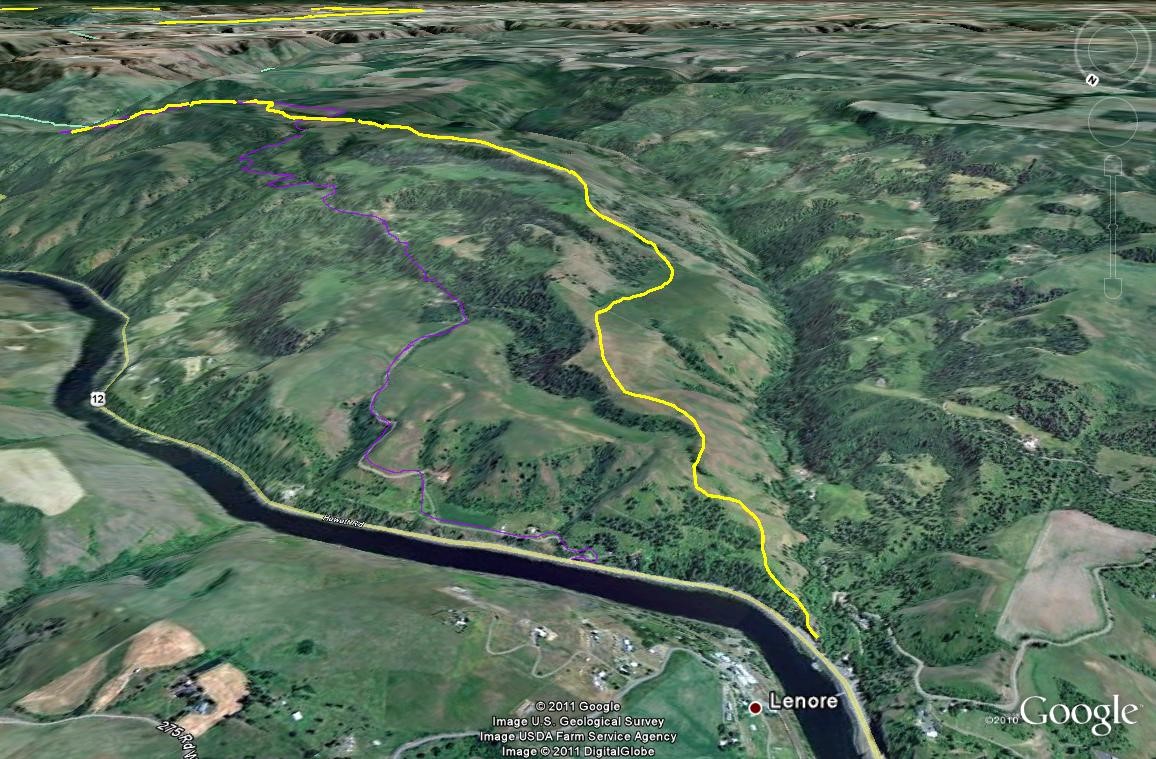
Figure 2. Angel Ridge looking South East from above Lenore. Route of Expedition in yellow, county road in purple. Jacks Creek entering the Clearwater River just west of where the expedition left the river.
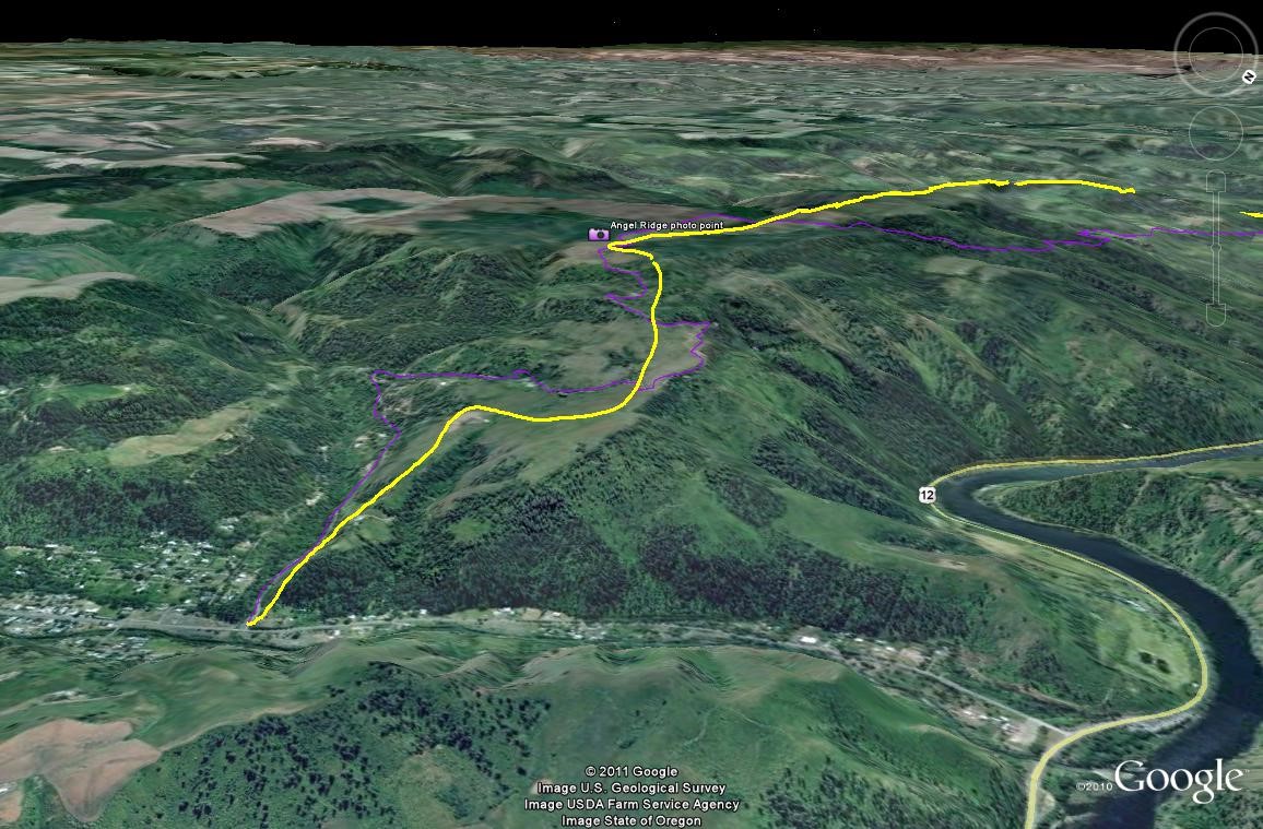
Figure 3. Route of afternoon of May 7, 1806. View of the mountains from the high point. Route traveled in yellow, county road in purple.
Up Angel Ridge and down to Peck
With no cache to retreive, they left the river and climbed to the south crossing over what today is called Angel Ridge. You can view their route from the Rest Area at Lenore, or leave Hwy 12 and cross the Lenore Bridge to the north side of the river and park above the railroad tracks and look back across the river. You can see the route they followed up the ridge to the east (left side) of Jacks Creek which enters the Clearwater near the bridge.
Figure 2 from Google Earth shows the L&C route in yellow. To drive, follow Eberhardt road, outlined in faint purple. Figure 3 shows the descent from Angel Ridge into the town of Peck.
Lewis: when we left the river and asscended the hills to the wright which are here mountains high. the face of the country when you have once ascended the river hills is perfectly level and partially covered with the longleafed pine. the soil is a dark rich loam thickly covered with grass and herbatious plants which afford a delightfull pasture for horses. in short it is a beautifull fertile and picteresque country.
Clark: The Spurs of the rocky mountains which were in view from the high plain to day were perfectly Covered with Snow. The Indians inform us that the Snow is yet So deep on the Mountains that we Shall not be able to pass them untill after the next full moon or about the first of June. others Set the time at a more distant period. this unwelcom intiligence to men confined to a diet of horsebeef and roots, and who are as anxious as we are to return to the fat plains of the Missouri, and thence to our native homes.
Ordway: dined and proceed on up the river ascended a high hill. Saw the rockey mountains covred with Snow. the country on these hills is verry rich, thinly covred with pitch pine, thick grass plants wild onions, &C. descended a hill down on a creek.